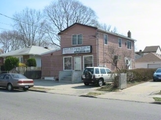
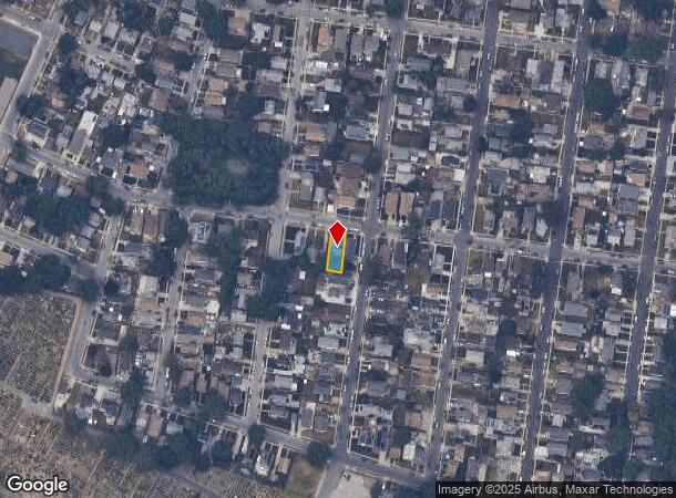
Property Record
1515 Kiefer Ave, Elmont, NY 11003
NEARBY LISTINGS FOR SALE OR LEASE
Property Detail
1515 Kiefer Ave
2089-32-501-00-0007-0
7-8
Commercialnec
Nassau
X
New York
36059C0205G
7
2025
0.09 AC
2025
Southern Nassau
405200
Long Island (New York)
3,112 SF
Nassau County-Suffolk County, NY
DEMOGRAPHICS near 1515 Kiefer Ave
1 Mile
3 Mile
5 Mile
2024 Total Population
33,728
299,193
830,743
2029 Population
32,098
285,533
791,961
Pop Growth 2024-2029
(4.83%)
(4.57%)
(4.67%)
Average Age
41
42
42
2024 Total Households
9,814
91,988
266,783
HH Growth 2024-2029
(5.01%)
(4.80%)
(4.91%)
Median Household Inc
$112,745
$116,659
$102,460
Avg Household Size
3.30
3.20
3.00
2024 Avg HH Vehicles
2.00
2.00
2.00
Median Home Value
$539,774
$655,199
$662,030
Median Year Built
1953
1949
1952
Nearby Places
- Restaurants
- Banks
- Shops
- Fitness
- Groceries
PUBLIC TRANSPORTATION
COMMUTER RAIL
Floral Park Station (Hempstead Branch - Long Island Rail Road)
DRIVE
WALK
Distance
Floral Park Station (Hempstead Branch - Long Island Rail Road)
6 min
2.7 mi
Stewart Manor Station (Hempstead Branch - Long Island Rail Road)
DRIVE
WALK
Distance
Stewart Manor Station (Hempstead Branch - Long Island Rail Road)
6 min
2.8 mi
AIRPORT
John F Kennedy International
DRIVE
WALK
Distance
John F Kennedy International
18 min
10.4 mi
LaGuardia
DRIVE
WALK
Distance
LaGuardia
25 min
13.1 mi
Newark Liberty International
DRIVE
WALK
Distance
Newark Liberty International
51 min
32.4 mi
Freight Ports
NY - Red Hook Container Terminal
DRIVE
WALK
Distance
NY - Red Hook Container Terminal
36 min
21.2 mi
Nearby Properties
Address
Land Use
TOTAL SIZE
Lot Size
Zoning
Address
Land Use
TOTAL SIZE
Lot Size
Zoning
129,378 SF
4.86 AC
R2A
Address
Land Use
TOTAL SIZE
Lot Size
Zoning
171,000 SF
2.76 AC
R2A
Address
Land Use
TOTAL SIZE
Lot Size
Zoning
99,814 SF
1.31 AC
R3-2
Address
Land Use
TOTAL SIZE
Lot Size
Zoning
252,665 SF
7.50 AC
R3-2
Address
Land Use
TOTAL SIZE
Lot Size
Zoning
170,000 SF
4.02 AC
R3-2
Address
Land Use
TOTAL SIZE
Lot Size
Zoning
78,380 SF
0.85 AC
R3-2
Address
Land Use
TOTAL SIZE
Lot Size
Zoning
155,000 SF
2.09 AC
R3A
Address
Land Use
TOTAL SIZE
Lot Size
Zoning
806 SF
84.15 AC
R2A
Address
Land Use
TOTAL SIZE
Lot Size
Zoning
260,000 SF
4.14 AC
R2
Address
Land Use
TOTAL SIZE
Lot Size
Zoning
122,740 SF
2.77 AC
R2
Address
Land Use
TOTAL SIZE
Lot Size
Zoning
1,020 SF
12.33 AC
R3-2
Address
Land Use
TOTAL SIZE
Lot Size
Zoning
32,000 SF
8.70 AC
M1-1
Address
Land Use
TOTAL SIZE
Lot Size
Zoning
108,051 SF
0.96 AC
C8-1
Address
Land Use
TOTAL SIZE
Lot Size
Zoning
53,700 SF
2.92 AC
R4-1
Address
Land Use
TOTAL SIZE
Lot Size
Zoning
59,426 SF
0.65 AC
C8-1
Address
Land Use
TOTAL SIZE
Lot Size
Zoning
150,150 SF
2.30 AC
R2
Address
Land Use
TOTAL SIZE
Lot Size
Zoning
35,000 SF
2.16 AC
R3-2
Address
Land Use
TOTAL SIZE
Lot Size
Zoning
63,976 SF
11.35 AC
R3-2
Address
Land Use
TOTAL SIZE
Lot Size
Zoning
53,100 SF
1.38 AC
R2
Address
Land Use
TOTAL SIZE
Lot Size
Zoning
105,036 SF
0.66 AC
M1-2
Address
Land Use
TOTAL SIZE
Lot Size
Zoning
73,300 SF
1.93 AC
R2
Address
Land Use
TOTAL SIZE
Lot Size
Zoning
52,000 SF
1.34 AC
R3-2
Address
Land Use
TOTAL SIZE
Lot Size
Zoning
57,000 SF
2.16 AC
R2A
Address
Land Use
TOTAL SIZE
Lot Size
Zoning
41,712 SF
0.51 AC
R2A
Address
Land Use
TOTAL SIZE
Lot Size
Zoning
29,346 SF
4.32 AC
R3-2
Address
Land Use
TOTAL SIZE
Lot Size
Zoning
97,200 SF
1.84 AC
R4B
Address
Land Use
TOTAL SIZE
Lot Size
Zoning
36,500 SF
2 AC
R2A
Address
Land Use
TOTAL SIZE
Lot Size
Zoning
32,000 SF
1.44 AC
R3X
Address
Land Use
TOTAL SIZE
Lot Size
Zoning
79,750 SF
2.66 AC
R3A
Address
Land Use
TOTAL SIZE
Lot Size
Zoning
1,677 SF
20.49 AC
R2A
The World's #1 Commercial Real Estate Marketplace
Connect with us
© 2025 CoStar Group
The information above has been obtained from sources believed reliable. While we do not doubt its accuracy we have not verified it and make no guarantee, warranty or representation about it. It is your responsibility to independently confirm its accuracy and completeness. Any projections, opinions, assumptions, or estimates used are for example only and do not represent the current or future performance of the property. The value of this transaction to you depends on tax and other factors which should be evaluated by your tax, financial, and legal advisors. You and your advisors should conduct a careful, independent investigation of the property to determine to your satisfaction the suitability of the property for your needs.